miggiddymatt.com › Hiking
A 1.6-mile loop in Madison County where the Appalachian Trail walks right through downtown, follows the French Broad River to a waterfall, then climbs 500 feet to three rocky overlooks. Short, genuinely earned, and worth the drive.
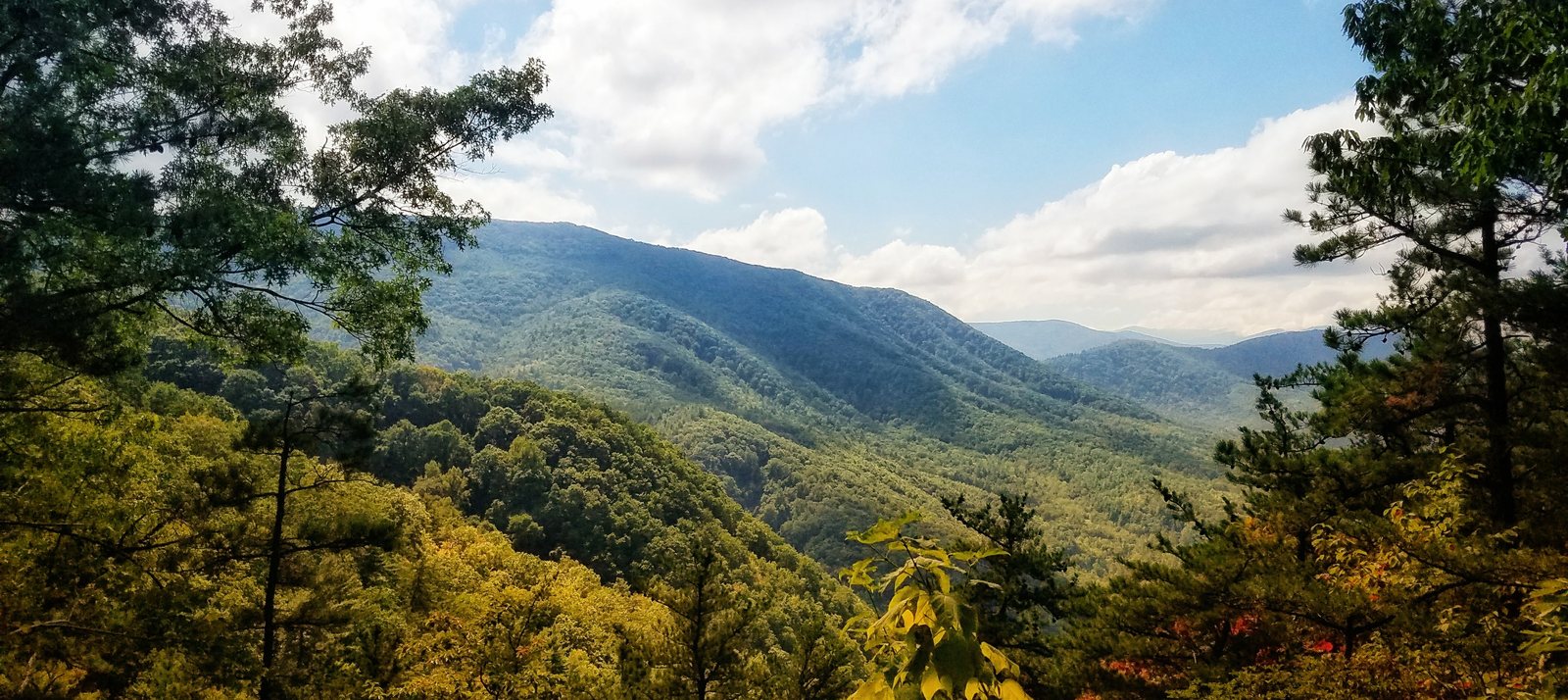
Hot Springs is one of those WNC towns that earns its reputation every time you visit. It's small, it sits right on the French Broad River, and the Appalachian Trail walks directly down the main street before crossing the bridge and climbing into the mountains. That last detail is what makes Lovers Leap special — it's one of the few places in the country where you can park downtown, grab coffee at one of the handful of storefronts, and be standing on a named section of the AT in under five minutes.
The loop starts at the Silvermine Trailhead, just across the river from downtown at the end of Silver Mine Road. From there you pick up the orange-blazed Lovers Leap Trail, which follows the French Broad upstream through a stretch of flat, pleasant riverbank trail before the climb begins. About a third of a mile in you'll pass a wide whitewater rapid, then the trail veers sharply left and starts ascending in earnest through a series of switchbacks. The footing is rocky and the slope is real — you gain roughly 500 feet over less than half a mile, which is the kind of pitch that makes your quads register a complaint.
The reward is three rocky outcroppings spaced along the ridge. The first overlook hits around 0.85 miles. The second — Lovers Leap proper — is at about 0.9 miles, a rocky precipice with a Cherokee legend attached and a clear view down to the French Broad winding below and the town spread out along its banks. The third is just past the summit. Views extend west to Hot Springs and north along the gentle meanders of the river. The rock drops off sharply, and the footing near the edge is loose — take it seriously.
The descent follows the orange connector back down to the Silvermine Trailhead to complete the loop. The whole hike takes about an hour at a steady pace, maybe 90 minutes if you spend time at the overlooks. After: the Spring Creek Tavern is a reliable post-hike stop. If you want to make a longer afternoon of it, the Appalachian Springs Resort hot springs are genuinely relaxing and a reasonable excuse to stay in Hot Springs longer than the hike requires.
Getting there: From Asheville, take I-26 W to US-25/70 toward Hot Springs — about 35 miles, 45 minutes. Cross the French Broad bridge into town, then turn immediately onto Silver Mine Road and follow it to the parking area at the end. The trail kiosk is right there. No fee, no reservations needed.
View on AllTrailsAt 5,892 feet on the Blue Ridge Parkway, Craggy Pinnacle offers some of the best panoramic views in western NC in under a mile of hiking. Best in mid-June when the Catawba rhododendrons bloom. The elevation change happens on the drive up.
The thing about Craggy is that you feel the altitude before you see the summit. The temperature drops noticeably on the drive up the Parkway — you're gaining over 3,500 feet from Asheville — and by the time you reach the Craggy Dome parking area at Milepost 364.1, it's reliably 15 to 20 degrees cooler than the city. On a hot August afternoon, that alone justifies the trip.
The Craggy Pinnacle Trail is short by any measure — under a mile round trip from the parking area, with only 252 feet of elevation gain. But the terrain it crosses is genuinely striking. The trail climbs through a dense, gnarled forest of twisted rhododendron and sweet birch that looks ancient, the branches draped in lichen and moss, the ground cushioned in thick green. Near the summit it opens into what's called a heath bald: an exposed, windswept expanse where trees can't get purchase, and where Catawba rhododendrons bloom in spectacular pink and purple waves in mid-June. The twisted birch just below the summit has become something of a photo landmark — it looks like a bonsai tree that got out of hand.
The summit has three small rocky overlooks with low rock walls to sit against. To the north you can see Mount Mitchell, the highest peak east of the Mississippi. To the west the ridge drops toward I-26 and Tennessee. To the south the Parkway winds away toward Asheville in the valley below. In clear conditions the views run 50+ miles in every direction. It's a strong candidate for the best accessible summit view in the Asheville area — and the short approach means it's worth doing even when you only have an hour.
Timing matters here. Come in late May and the rhododendron buds are still closed. Come in late June and you've missed peak bloom. The window is usually one to two weeks in mid-June. Locals post bloom updates obsessively — the Blue Ridge Parkway's social media accounts and the Explore Asheville site both track it in season. If you can plan around the bloom, do it. If not, the views are worth the trip in any season the Parkway is open.
Getting there: Drive north on the Blue Ridge Parkway from Asheville. The Craggy Dome parking area is at Milepost 364.1, about 18 miles from the Folk Art Center near US-70. The trail begins at the stone stairs at the south end of the parking lot. Free, no fee. This section of the Parkway closes frequently in winter — check Parkway status before driving between November and April.
View on AllTrailsAt Milepost 418.8 on the Blue Ridge Parkway, a high-altitude valley with a ghostly name hides two waterfalls and the best late-summer blueberry picking in the mountains. The lower falls are 0.3 miles from the car. The upper falls are worth the extra mile.
The name needs explaining first. Centuries ago a massive windstorm flattened most of the trees in this high-altitude valley, leaving a field of moss-covered stumps that settlers thought looked like gravestones. A 1925 fire finished most of what the wind started. The forest has been slowly recovering ever since — which is why Graveyard Fields looks unlike anywhere else on the Parkway. It's open and sun-drenched where most Parkway hikes are forested, with low blueberry and blackberry bushes spreading across a wide valley flanked by 6,000-foot peaks.
The trailhead is at the Graveyard Fields Overlook at Milepost 418.8, about 37 miles southwest of Asheville — roughly 10 miles past Mt. Pisgah. There are actual restrooms at the parking lot, which is notable and rare on the Parkway. The lot fills fast on summer and fall weekends. Get there before 9am or plan to circle.
The trail descends stone stairs from the parking lot, threads through a rhododendron tunnel, and crosses Yellowstone Prong on a wooden bridge. At the junction, a right turn takes you 0.3 miles to Second Falls (also called Lower Falls) — a wide, multi-tiered cascade that drops into a clear pool popular for swimming on hot days. The approach is easy and the falls are immediately gratifying. Most visitors stop here and turn back, which means everything past this point is noticeably quieter.
The Upper Falls are worth the extra mile. The trail continues through the open valley, through blueberry and blackberry bushes, and eventually climbs more steeply over rocky terrain to a 40-foot cascade in two sections — a main drop and a narrow chute down polished rock. The signage past the lower falls is minimal, so pay attention at intersections. The round trip to both falls runs about 3.3 miles total with around 400 feet of elevation change — a couple of hours at an easy pace.
August is the best month to visit if blueberries are any part of the calculation. The bushes along the main loop are loaded and park rules allow picking up to one gallon per visit. It's a legitimate reason to slow down and spend more time in the valley than the waterfall destinations alone might justify.
Getting there: Follow the Blue Ridge Parkway southwest from Asheville to Milepost 418.8. The overlook and parking lot are well-marked. This section of the Parkway closes in winter and during high-wind events — check current conditions before driving. Free, no entrance fee.
View on AllTrailsA 535-million-year-old granite monolith 25 miles southeast of Asheville. The Hickory Nut Falls trail leads to the base of a 404-foot waterfall — one of the tallest east of the Mississippi. Yes there's a fee. Yes it's still worth going.
Chimney Rock is unusual in the WNC outdoor landscape because it costs money to enter. Most of the trails around Asheville are free — Blue Ridge Parkway, national forest, Pisgah, all of it. Chimney Rock is a state park with a privately operated attraction built around it, which means a $17 adult entrance fee that can feel jarring if you're used to the no-fee norm. Get over it. The park earns it, and the waterfall alone justifies the drive.
Hickory Nut Falls is 404 feet tall. That makes it one of the highest waterfalls east of the Mississippi, and the statistic doesn't quite communicate the experience — standing at the base and looking up at that much vertical water is something that doesn't reduce to a photograph. The trail to get there is 1.4 miles round trip from the lower parking area, with about 200 feet of elevation gain through mature mixed hardwood forest along the base of the gorge cliffs. It's genuinely moderate — some rocky sections and a small set of stairs near the base of the falls — but accessible to most people. Interpretive signs along the route explain the geology and ecology, which is either welcome context or easy to walk past depending on your mood.
If you're paying the entrance fee anyway, climb to Chimney Rock itself. The elevator option is exactly what it sounds like: a 26-story elevator carved through solid granite in 1949, which is either impressive engineering or mild claustrophobia depending on your disposition. The alternative is the Outcroppings Trail — 500+ stairs straight up. The summit of Chimney Rock sits at 2,280 feet and looks out across 75 miles of Blue Ridge ridges with Lake Lure shimmering in the gorge below. The Exclamation Point Trail continues from the summit to even broader views at 2,480 feet.
Two film footnotes worth knowing: the climactic chase scene from The Last of the Mohicans (1992) was filmed on the Skyline Trail and at Hickory Nut Falls — Daniel Day-Lewis ran across that gorge. Nearby Lake Lure appeared in Dirty Dancing (1987). Neither fact is necessary to enjoy the park, but they come up reliably when you're on the trail with strangers.
Practical notes: the Skyline Trail above Exclamation Point was closed due to Hurricane Helene damage — check the park website for current status. The park opens at 8:30am; last tickets are sold at 4:30–5pm depending on season. On busy fall weekends, buying tickets online ahead avoids the gate line.
Getting there: From Asheville, take I-240 East to US-74A toward Lake Lure. Follow US-74A approximately 25 miles to the park entrance at 431 Main Street, Chimney Rock, NC 28720. The drive through Hickory Nut Gorge on 74A is scenic on its own. About 45 minutes from downtown Asheville.
View on AllTrailsA short but steep hike to the ruins of the old Rattlesnake Lodge on the Blue Ridge Parkway — 900 feet of climbing in under 3 miles, with views that explain why someone built a summer retreat up here in 1904.
Rattlesnake Lodge sits at about 3,100 feet on the slopes of Snyder Mountain just off the Blue Ridge Parkway north of Asheville. The trail gains most of its 900 feet in a fairly direct assault up the mountain, which in late October with the leaves mostly down means you're working hard but getting paid in views the whole way.
The lodge itself is long gone — burned in the 1920s — but the stone foundations, cisterns, and terraced garden walls are still there and remarkably intact. You can spend a while exploring the footprint of what was apparently a substantial summer estate.
The Mountains-to-Sea Trail passes through on its way across North Carolina. The fall color that year was exceptional — peak timing, warm afternoon light, the kind of day that makes you feel lucky to live within driving distance of this.
View on Strava ›