Matthew Self
Husband, father, mountain biker, pit master, and reluctant gardener. Writing about life in western North Carolina — the trails, the smoke, the soil, and everything in between.
I came to disc golf late and approached it the wrong way — by starting at Richmond Hill. Here's what I've learned about the courses around Asheville, ranked by how likely they are to destroy your confidence on the first visit.
Disc golf is one of those sports that sounds extremely casual until someone takes you to a real course and you spend two hours hiking steep mountain terrain while repeatedly throwing a plastic disc into the woods. In western North Carolina, "real course" often means elevation changes that would be considered aggressive on a hiking trail.
I started playing maybe two years ago, mostly as an excuse to be outside with friends on a weekday afternoon. What I didn't expect was to actually get hooked. The mechanics are interesting enough to stay challenging without requiring years of athletic investment, the courses are free, and you can carry everything you need in a small bag. It's the most accessible hard sport I've found.
The Asheville area has a genuinely excellent disc golf scene — the WNC Disc Golf Association (WNCDGA) runs regular events and maintains several of the local courses, and there are enough varied options within thirty minutes of downtown that you could play a different course every weekend for months. Here's my honest take on the three I keep coming back to, in order from "bring a friend who's done this before" to "maybe start somewhere easier."
Lake Julian — start here. Flat-ish, scenic, dog-friendly, and the poison ivy situation is manageable. The course wraps around the lake and mixes open waterfront holes with some tighter wooded sections. Twenty holes. A good place to learn the basic throws without immediately losing three discs in a ravine.
Richmond Hill — the local classic. 18 holes in Richmond Hill Park, tight and wooded with significant elevation change. This is the course the WNCDGA calls home and it regularly hosts PDGA tournaments. Beautiful, but it will punish loose throws. That gorge on the back nine is not forgiving.
Mars Hill — for when you're ready. Twenty minutes north of Asheville on the Mars Hill University campus. Rated Hard on UDisc. Drastic elevation, quick greens, mandatory throws (mandos), and navigation that requires either a local guide or a printed map. The views from hole 7 are worth whatever score you post.
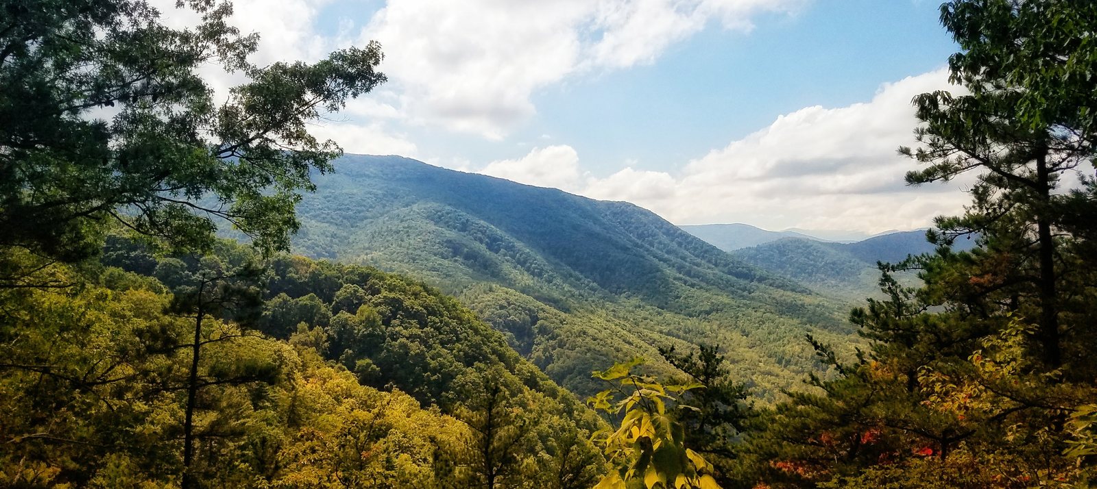
18 holes, 184 acres, tight wooded fairways, elevation changes on nearly every hole, and a poison ivy situation that is not theoretical. Richmond Hill is the best disc golf course in the Asheville area and also the least forgiving.
Richmond Hill Park sits just north of downtown Asheville, and the disc golf course occupies a heavily wooded, deeply hilly section of its 184 acres. The original course dates to 2000, was redesigned in 2006 when the layout had to move to make way for an armory, and took a significant hit from Hurricane Helene in 2024 before reopening with upgrades including new concrete tee pads. It's been a local institution for twenty-five years and it still earns every bit of its reputation.
The course plays differently than almost anything else in the area. The canopy is dense — mostly pine and hardwood — which means the shots that look open from the tee are rarely as open as they appear. Seventeen of the eighteen holes have alternate pin positions, so the layout changes regularly and you can play the same course multiple times without it feeling identical. The elevation changes are not gentle. There are holes where you're throwing down into a gorge and holes where you're throwing uphill into a tunnel of trees, and the course designer was clearly not interested in making any of it easy.
What makes Richmond Hill special is that it rewards precision over power. This isn't a course where you can muscle your way through. The tight fairways punish anything that drifts, and the rough — which is where the poison ivy lives — is genuinely punishing. After a few rounds you start to develop a feel for which holes are forgiving and which ones are traps, and that learning curve is part of what keeps people coming back.
The WNCDGA runs Tuesday Afternoon Random Draw Doubles here regularly, which is a good way to get paired with experienced players who can show you the lines. For a first visit, bring someone who's been before, wear long pants regardless of the weather, and don't try to hero any of the gorge shots until you've seen where the disc goes when it misses.
View on UDisc ›18 holes on a university campus 20 minutes north of Asheville. Rated Hard. Six par fours. Signature hole 7 with a 400-foot top-of-the-world shot overlooking Bailey Mountain. Bring a map or bring a local.
Mars Hill University is about twenty minutes north of Asheville on US-19/23, and the disc golf course wraps around the back of the campus across approximately thirty acres of mountain terrain. The layout includes 43 tee pads and 34 basket placements, which means the course can be configured in a staggering number of ways — the version you play today might be meaningfully different from the version you played six months ago.
The course is rated Hard on UDisc, and that rating is accurate. There are six par fours, which is unusual in disc golf and signals right away that this isn't a course designed for casual rounds. The greens are fast — the campus is maintained to a high standard and the grass is kept short — which means approaches that would be routine on other courses become delicate. Miss the green at Mars Hill and you're often dealing with a significant slope.
The signature feature is hole 7. From the tee, you're standing at elevation looking out over a valley with Bailey Mountain in the background, and the throw is a long shot out into open air before the disc has to find its way back to the basket. When conditions are right and the shot comes off, it's one of the most satisfying throws in the area. When it doesn't come off, you're hiking.
Navigation is the main challenge for first-timers — the course winds through the campus in a way that isn't intuitive, and the signage is adequate but not generous. The advice from every veteran Mars Hill player is the same: bring someone who's played it before, or at minimum take a photo of the map at hole 1 before you start. The holes between 11 and 13 in particular have a way of sending unfamiliar players in the wrong direction entirely.
The reward for figuring it out is one of the more distinctive playing experiences in western NC. The blend of open manicured fairways, tight wooded holes, elevation drama, and mandatory throws keeps every round interesting. After your round, the town of Mars Hill has a few bars and restaurants within walking distance of campus, which is a reasonable way to finish a hard afternoon.
View on UDisc ›20 holes around a lake in south Asheville. Dog-friendly, cart-friendly, flat enough to be approachable, and interesting enough to be worth repeating. The best entry point to disc golf in the area.
Lake Julian Park is in Arden, about ten minutes south of downtown Asheville, and the disc golf course wraps around the lake and through the surrounding park. The course was originally nine holes and expanded to eighteen in 2017 — it now plays twenty holes, which is an unusual number that always seems to catch people off guard when they think they're almost done.
What makes Lake Julian the right starting point for newer players is that the terrain is actually manageable. The course has some elevation and some tight wooded holes, but it's not designed to be brutal. Several of the holes along the water give you room to work with, and the overall layout is forgiving enough that you can focus on developing your throws rather than just surviving the course.
The lake elements add a visual interest that Richmond Hill and Mars Hill don't have — there's something inherently pleasant about standing at a tee with water in the background, even if a bad throw means you're watching your disc skip across the surface. Water is in play on a number of holes, which adds a real penalty for errors without being relentlessly punishing the way the gorge at Richmond Hill can be.
Practically: Lake Julian is dog-friendly and cart-friendly, which opens it up to a wider crowd than the steep wooded courses. The park itself is a legitimate destination — there's a lake loop trail, fishing, and picnic areas — so it's easy to make a full afternoon of it. The course shares the park with hikers and walkers, so you're threading your rounds around other users, but it's generally well-managed and the traffic isn't a problem on weekday mornings.
The poison ivy situation at Lake Julian is present but less aggressive than Richmond Hill. Still worth long pants on the wooded holes, but the risk of blundering into a patch is lower. For a first round, this is where to go.
View on UDisc ›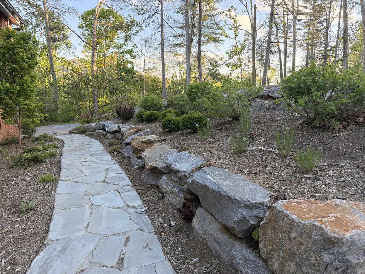
Building out the rock garden beds meant learning which plants belong here and which ones just look good on the label at the nursery. A field guide to what's working — and what the deer ate anyway.
When we started building out the rock garden — the flagstone path, the granite retaining walls, the beds carved into the slope — I made the mistake most new mountain gardeners make: I went to the nursery without a plan and bought whatever looked beautiful. Some of it survived. Most of what survived is native.
Western North Carolina sits in zone 7a, which sounds straightforward until you realize that elevation, slope aspect, and shade can each shift your microclimate by a full zone. What thrives on the sunny south-facing side of the wall dies in the moist shade twenty feet away. After a few seasons of trial and error, here's what's actually earning its place in our beds.
Eastern bluestar (Amsonia tabernaemontana) — This is the one I keep coming back to. Soft powder-blue star-shaped flowers in late spring, feathery willow-like foliage through summer, and then brilliant golden-yellow fall color that rivals anything in the garden. It's fully drought-tolerant once established, deer resistant, and it fills in beautifully without becoming aggressive. The photo from this spring shows it just coming into bloom alongside the rock wall — that blue against the gray granite is the most satisfying combination in the whole yard.
Sempervivum (hens and chicks) — Strictly speaking, sempervivums are European, not native to WNC, but they've earned honorary membership by thriving in the one place nothing else will: the gaps between the granite boulders where there's essentially no soil. They've colonized a whole section of the rock wall and I've done nothing for them. The dark burgundy variety overwinters beautifully and the rosette structure looks good even in February.
Black and blue salvia (Salvia guaranitica) — The dark-leafed, black-stemmed salvia in the upper bed is technically South American, but it performs like a native here — returning reliably each spring, growing to four feet, and blooming deep blue-violet from late summer until hard frost. The hummingbirds are unreasonably enthusiastic about it. It seeds around gently, so I let it naturalize where it wants.
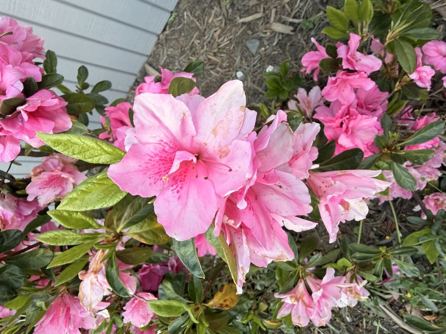
Native azaleas — The pink azaleas along the house foundation are not native — they're the typical hybrid garden variety — but if you're in WNC and want to go native, flame azalea (Rhododendron calendulaceum) is the one to find. Orange, yellow, and red flowers, no fragrance, and blooms two weeks later than the hybrids when everything else has faded. I'm planning to add some to the upper beds this fall.
What the deer ate — Hostas, echinacea, and both times I tried to establish trillium. The rock garden's slope gives some protection but anything in the open is fair game after midnight. The lesson I keep relearning is that deer-resistant isn't the same as deer-proof, and that the most reliable strategy is to plant so much of what they avoid that the losses don't matter.
The plan this year is to add more amsonia, some native columbine in the shadier sections, and a few clumps of Carolina lupine (Thermopsis villosa) on the upper slope where it can get the full sun it wants. The yard project is very much ongoing.
Zone 7a gardening in the western NC mountains is humbling. The deer think my raised beds are a buffet, the late frosts don't care about my timeline, and I am once again growing more zucchini than any household needs.
The flagstone path through the front beds is finally finished and it's changed how I relate to the whole garden. Having a defined route through it means I actually walk it every morning instead of just glancing from the deck.
This spring I went a little overboard. The azaleas along the house are doing exactly what azaleas do in April — absolutely exploding with pink. The sempervivums tucked into the rock wall are spreading nicely into the gaps. The eastern bluestar (amsonia) I planted last fall came back strong — that soft blue against the gray granite is something.
The vegetable situation is more complicated. I put in tomatoes a week before the last frost advisory because I was impatient. Covered them with frost cloth and got lucky. The zucchini is already doing what zucchini does. Neighbors beware.
The deer pressure this year has been significant. I've given up on hostas in any unprotected area. The raised beds are doing fine but everything at ground level is fair game after dark.
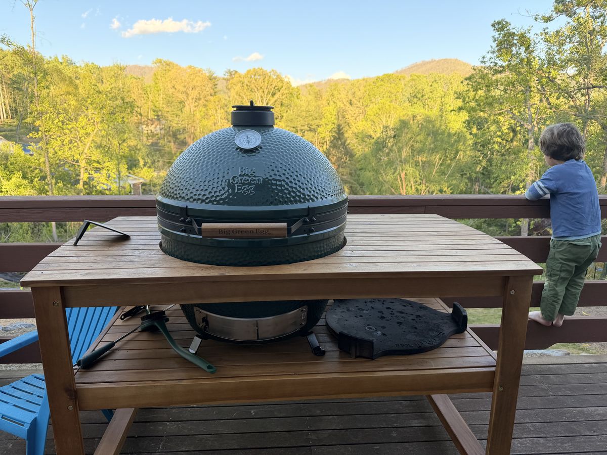
A spatchcocked bird at 400°F on the Big Green Egg with indirect heat. Crispy skin, juicy meat all the way through, done in under an hour. Why doesn't everyone cook chicken this way?
I've been roasting chickens for years — in a cast iron skillet, in a Dutch oven, on a rack in the oven — and they've always been fine. Good, even. But not remarkable. Then I started doing them on the Big Green Egg and now I can't go back.
The method is spatchcock (also called butterfly), which means removing the backbone so the bird lays flat. It sounds more dramatic than it is — a pair of kitchen shears, two cuts along either side of the spine, and you're done. Press the bird flat and it's ready to go. The payoff is that the breast and thigh finish cooking at the same time, which is the fundamental challenge of roasting a whole chicken.
The setup: Get the Egg dialed in at 400°F running indirect — convEGGtor plate in, grill grate on top. I use a mix of lump charcoal and a small chunk of peach or cherry wood for a light smoke that doesn't overpower the chicken. This isn't a long smoke; it's a high-heat roast with a little wood flavor in the background.
The prep: Pat the bird dry — this is the step most people skip and it's the one that matters most for crispy skin. Dry skin browns; wet skin steams. I use either a Meat Church Holy Gospel rub or just go simple: salt, pepper, garlic powder, and whatever fresh herbs are growing. Get some compound butter under the skin over the breast if you want to go the extra mile — softened butter with thyme, lemon zest, and garlic pressed under the skin before cooking.
The cook: Spatchcocked bird goes on the grate skin-side up, no flipping. At 400°F indirect, a standard 4-pound chicken takes 45 to 55 minutes. You're looking for 165°F in the thickest part of the thigh, but the skin will tell you most of what you need to know — when it's deep golden brown and pulling tight, you're close.
The rest: Ten minutes under loose foil. This isn't optional. The juices redistribute and the carry-over heat finishes the job.
The result is a chicken with skin that shatters when you cut into it, meat that's genuinely juicy through to the bone, and a faint smoke that makes you feel like you actually cooked something. I do one of these about every two weeks now. It's become the house standard.
Pork shoulder at 225° for fourteen hours while the neighborhood slowly loses its mind. Notes on fire management, bark formation, and why I keep coming back to lump charcoal over briquettes.
There's a particular kind of patience required for low-and-slow barbecue that I didn't know I had until I got the Big Green Egg. It's not passive patience — you're checking temps, adjusting vents, managing the fire — but it forces you to slow down in a way that most weekend activities don't.
The cook started at 6am. Eight-pound bone-in pork shoulder, dry-rubbed the night before with brown sugar, smoked paprika, garlic powder, black pepper, and a healthy dose of kosher salt. The Egg was dialed in at 225°F running lump charcoal with a few chunks of apple wood tucked in for smoke.
The stall hit around 165°F internal — that long plateau where the evaporative cooling of the meat matches the heat input and the temperature just... stops moving. This is where the impatient cook reaches for the foil. I waited it out. Two hours of nothing, then a slow climb to 203°F where the bone slides clean out and the whole thing falls apart in your hands.
Rested for an hour under foil and a couple of towels in a cooler. Pulled it apart and served it plain — no sauce needed when the bark is right. The mountains in the background and a cold beer in hand made it a perfect Sunday.
Six hours, three phases, one rack of baby backs that falls off the bone. I followed the Meat Church approach as closely as I could on the Big Green Egg. Here's how it went.
The 3-2-1 method is named for its timing: three hours of smoke, two hours wrapped in foil, one hour unwrapped to set the bark and sauce. It's the most forgiving rib method I know of — the foil phase does the heavy lifting on tenderness and there's enough buffer in the timing that a half-hour either way doesn't ruin anything. Meat Church out of Waxahachie, Texas has become my go-to reference for this cook.
The prep — the night before: Pull the membrane off the bone side of the rack. This step is non-negotiable — that thin silver membrane blocks smoke penetration and you'll never get it off cleanly once it's cooked. Grab it with a paper towel at one end and it peels right off. Rub the bone side with Meat Church Honey Hog Hot, then flip and hit the meat side with a second coat. Wrap in plastic and refrigerate overnight. The rub sets up into a tacky crust that holds smoke and creates the foundation of the bark.
Phase 1 — three hours of smoke: Get the Egg running at 225°F indirect with the convEGGtor in. I used a combination of lump charcoal and apple wood chunks — fruit wood is the right call for pork; hickory or oak can be a little heavy on ribs over a long cook. Ribs go on bone-side down, no touching for three hours. Spritz with apple juice every 45 minutes if you want to keep moisture on the surface and encourage bark development. By the end of hour three you're looking for a deep mahogany color and the beginning of a bark that holds its shape when you press it.
Phase 2 — two hours in foil: This is the Meat Church signature move. Lay out two long sheets of heavy foil and create a bed of brown sugar and butter — a good handful of brown sugar, four or five pats of butter, and a bead of Texas Pepper Jelly (apple and brown sugar flavor) if you can find it. Place the ribs meat-side down on that sweet mixture, fold up three sides of the foil, pour in a quarter cup of apple juice as a braising liquid, then seal the last side. Back on the Egg at 225°F for two hours. The target is 203-205°F internal and the meat pulling back from the bone ends. The foil environment steams the ribs and drives the collagen breakdown that makes them pull-tender.
Phase 3 — one hour unwrapped: Pull the ribs from the foil carefully — there's a lot of hot liquid in there. Sauce both sides with your BBQ sauce of choice; Meat Church uses a 3:1 mix of their favorite BBQ sauce and Texas Pepper Jelly Rib Candy. Back on the grate at 225°F for the final hour, letting the sauce tighten and caramelize into a glaze. This is the phase where the bark firms back up and everything comes together.
After a ten-minute rest the ribs should have a clean pull from the bone — not fall-off, which actually indicates they went too far, but a firm gentle tug that releases clean. These were the best ribs I've made. The Meat Church rubs are worth seeking out; the Honey Hog Hot has exactly the right balance of sweet heat that plays beautifully against the apple and brown sugar in the wrap phase.
Full credit to Meat Church's baby back rib recipe for the core method — I adapted it for the Egg but the bones of the technique are theirs.
10.45 miles and 1,715 feet of climbing at Black Mountain — one of those rides where the trail wins and you're okay with it.
Kitsuma is one of those trails that has a reputation in Black Mountain — and on this August morning it earned every bit of it. The heat was already building by 9am and the trail wasted no time reminding me why I'd been avoiding the climbing sections all summer.
The Kitsuma trail itself is relentless uphill — tight switchbacks through rhododendron tunnels, loose rocks that find a way under your front wheel at the worst possible moment. By the time I hit the top I was properly cooked. But the descent off the back side is one of the best pieces of singletrack in the area — fast, flowy, with just enough tech to keep you honest.
Nearly 1,700 feet of climbing in 10 miles on a late August day in western NC. The trail won. I came back for more two weeks later.
View on Strava ›A November ride in Pisgah — 9.4 miles, 1,234 feet of climbing, and the kind of late-autumn light through bare hardwoods that makes you forget how cold your hands are.
November riding in Pisgah is its own thing. The crowds are gone, the leaves are down so you can actually see the ridge lines through the trees, and the air is cold enough that you're working to stay warm on the climbs and freezing on the descents. Gloves are non-negotiable.
Spencer Gap trail is a classic Pisgah climb — a long, steady grind up to the gap on a jeep road before things get more interesting. Mark set a pace that was slightly too fast for comfort and exactly fast enough to be satisfying.
The descent back down was fast and loose — the kind of Pisgah riding where the trail surface changes every thirty seconds and you're making micro-decisions constantly. A proper late-season ride.
View on Strava ›14 miles, 1,594 feet of climbing, and a navigational situation that turned a planned 2-hour ride into nearly 3. Dupont State Recreational Forest is beautiful. It's also easy to get turned around in.
Dupont has a trail network that looks manageable on the map and is absolutely not manageable when you're deep in it without cell service and every junction looks like the last one. This was supposed to be a straightforward loop. It became an adventure.
The forest itself is stunning — hardwoods, waterfalls, granite domes, and singletrack that ranges from flowy gravel paths to chunky technical descents. The problem is that the trail intersections are numerous and not always obvious, and on a September day when you're tired and a little dehydrated, left and right start to lose meaning.
I added about 3 miles I didn't plan on. The good news is that those extra miles included some of the best trail in the park — a long ridge traverse with views out toward the south that I wouldn't have found if I'd stayed on route. Getting lost in Dupont has its upsides.
View on Strava ›A 1.6-mile loop in Madison County where the Appalachian Trail walks right through downtown, follows the French Broad River to a waterfall, then climbs 500 feet to three rocky overlooks. Short, genuinely earned, and worth the drive.
Hot Springs is one of those WNC towns that earns its reputation every time you visit. It's small, it sits right on the French Broad River, and the Appalachian Trail walks directly down the main street before crossing the bridge and climbing into the mountains. That last detail is what makes Lovers Leap special — it's one of the few places in the country where you can park downtown, grab coffee at one of the handful of storefronts, and be standing on a named section of the AT in under five minutes.
The loop starts at the Silvermine Trailhead, just across the river from downtown at the end of Silver Mine Road. From there you pick up the orange-blazed Lovers Leap Trail, which follows the French Broad upstream through a stretch of flat, pleasant riverbank trail before the climb begins. About a third of a mile in you'll pass a wide whitewater rapid, then the trail veers sharply left and starts ascending in earnest through a series of switchbacks. The footing is rocky and the slope is real — you gain roughly 500 feet over less than half a mile, which is the kind of pitch that makes your quads register a complaint.
The reward is three rocky outcroppings spaced along the ridge. The first overlook hits around 0.85 miles. The second — Lovers Leap proper — is at about 0.9 miles, a rocky precipice with a Cherokee legend attached and a clear view down to the French Broad winding below and the town spread out along its banks. The third is just past the summit. Views extend west to Hot Springs and north along the gentle meanders of the river. The rock drops off sharply, and the footing near the edge is loose — take it seriously.
The descent follows the orange connector back down to the Silvermine Trailhead to complete the loop. The whole hike takes about an hour at a steady pace, maybe 90 minutes if you spend time at the overlooks. After: the Spring Creek Tavern is a reliable post-hike stop. If you want to make a longer afternoon of it, the Appalachian Springs Resort hot springs are genuinely relaxing and a reasonable excuse to stay in Hot Springs longer than the hike requires.
Getting there: From Asheville, take I-26 W to US-25/70 toward Hot Springs — about 35 miles, 45 minutes. Cross the French Broad bridge into town, then turn immediately onto Silver Mine Road and follow it to the parking area at the end. The trail kiosk is right there. No fee, no reservations needed.
View on AllTrailsAt 5,892 feet on the Blue Ridge Parkway, Craggy Pinnacle offers some of the best panoramic views in western NC in under a mile of hiking. Best in mid-June when the Catawba rhododendrons bloom. The elevation change happens on the drive up.
The thing about Craggy is that you feel the altitude before you see the summit. The temperature drops noticeably on the drive up the Parkway — you're gaining over 3,500 feet from Asheville — and by the time you reach the Craggy Dome parking area at Milepost 364.1, it's reliably 15 to 20 degrees cooler than the city. On a hot August afternoon, that alone justifies the trip.
The Craggy Pinnacle Trail is short by any measure — under a mile round trip from the parking area, with only 252 feet of elevation gain. But the terrain it crosses is genuinely striking. The trail climbs through a dense, gnarled forest of twisted rhododendron and sweet birch that looks ancient, the branches draped in lichen and moss, the ground cushioned in thick green. Near the summit it opens into what's called a heath bald: an exposed, windswept expanse where trees can't get purchase, and where Catawba rhododendrons bloom in spectacular pink and purple waves in mid-June. The twisted birch just below the summit has become something of a photo landmark — it looks like a bonsai tree that got out of hand.
The summit has three small rocky overlooks with low rock walls to sit against. To the north you can see Mount Mitchell, the highest peak east of the Mississippi. To the west the ridge drops toward I-26 and Tennessee. To the south the Parkway winds away toward Asheville in the valley below. In clear conditions the views run 50+ miles in every direction. It's a strong candidate for the best accessible summit view in the Asheville area — and the short approach means it's worth doing even when you only have an hour.
Timing matters here. Come in late May and the rhododendron buds are still closed. Come in late June and you've missed peak bloom. The window is usually one to two weeks in mid-June. Locals post bloom updates obsessively — the Blue Ridge Parkway's social media accounts and the Explore Asheville site both track it in season. If you can plan around the bloom, do it. If not, the views are worth the trip in any season the Parkway is open.
Getting there: Drive north on the Blue Ridge Parkway from Asheville. The Craggy Dome parking area is at Milepost 364.1, about 18 miles from the Folk Art Center near US-70. The trail begins at the stone stairs at the south end of the parking lot. Free, no fee. This section of the Parkway closes frequently in winter — check Parkway status before driving between November and April.
View on AllTrailsAt Milepost 418.8 on the Blue Ridge Parkway, a high-altitude valley with a ghostly name hides two waterfalls and the best late-summer blueberry picking in the mountains. The lower falls are 0.3 miles from the car. The upper falls are worth the extra mile.
The name needs explaining first. Centuries ago a massive windstorm flattened most of the trees in this high-altitude valley, leaving a field of moss-covered stumps that settlers thought looked like gravestones. A 1925 fire finished most of what the wind started. The forest has been slowly recovering ever since — which is why Graveyard Fields looks unlike anywhere else on the Parkway. It's open and sun-drenched where most Parkway hikes are forested, with low blueberry and blackberry bushes spreading across a wide valley flanked by 6,000-foot peaks.
The trailhead is at the Graveyard Fields Overlook at Milepost 418.8, about 37 miles southwest of Asheville — roughly 10 miles past Mt. Pisgah. There are actual restrooms at the parking lot, which is notable and rare on the Parkway. The lot fills fast on summer and fall weekends. Get there before 9am or plan to circle.
The trail descends stone stairs from the parking lot, threads through a rhododendron tunnel, and crosses Yellowstone Prong on a wooden bridge. At the junction, a right turn takes you 0.3 miles to Second Falls (also called Lower Falls) — a wide, multi-tiered cascade that drops into a clear pool popular for swimming on hot days. The approach is easy and the falls are immediately gratifying. Most visitors stop here and turn back, which means everything past this point is noticeably quieter.
The Upper Falls are worth the extra mile. The trail continues through the open valley, through blueberry and blackberry bushes, and eventually climbs more steeply over rocky terrain to a 40-foot cascade in two sections — a main drop and a narrow chute down polished rock. The signage past the lower falls is minimal, so pay attention at intersections. The round trip to both falls runs about 3.3 miles total with around 400 feet of elevation change — a couple of hours at an easy pace.
August is the best month to visit if blueberries are any part of the calculation. The bushes along the main loop are loaded and park rules allow picking up to one gallon per visit. It's a legitimate reason to slow down and spend more time in the valley than the waterfall destinations alone might justify.
Getting there: Follow the Blue Ridge Parkway southwest from Asheville to Milepost 418.8. The overlook and parking lot are well-marked. This section of the Parkway closes in winter and during high-wind events — check current conditions before driving. Free, no entrance fee.
View on AllTrailsA 535-million-year-old granite monolith 25 miles southeast of Asheville. The Hickory Nut Falls trail leads to the base of a 404-foot waterfall — one of the tallest east of the Mississippi. Yes there's a fee. Yes it's still worth going.
Chimney Rock is unusual in the WNC outdoor landscape because it costs money to enter. Most of the trails around Asheville are free — Blue Ridge Parkway, national forest, Pisgah, all of it. Chimney Rock is a state park with a privately operated attraction built around it, which means a $17 adult entrance fee that can feel jarring if you're used to the no-fee norm. Get over it. The park earns it, and the waterfall alone justifies the drive.
Hickory Nut Falls is 404 feet tall. That makes it one of the highest waterfalls east of the Mississippi, and the statistic doesn't quite communicate the experience — standing at the base and looking up at that much vertical water is something that doesn't reduce to a photograph. The trail to get there is 1.4 miles round trip from the lower parking area, with about 200 feet of elevation gain through mature mixed hardwood forest along the base of the gorge cliffs. It's genuinely moderate — some rocky sections and a small set of stairs near the base of the falls — but accessible to most people. Interpretive signs along the route explain the geology and ecology, which is either welcome context or easy to walk past depending on your mood.
If you're paying the entrance fee anyway, climb to Chimney Rock itself. The elevator option is exactly what it sounds like: a 26-story elevator carved through solid granite in 1949, which is either impressive engineering or mild claustrophobia depending on your disposition. The alternative is the Outcroppings Trail — 500+ stairs straight up. The summit of Chimney Rock sits at 2,280 feet and looks out across 75 miles of Blue Ridge ridges with Lake Lure shimmering in the gorge below. The Exclamation Point Trail continues from the summit to even broader views at 2,480 feet.
Two film footnotes worth knowing: the climactic chase scene from The Last of the Mohicans (1992) was filmed on the Skyline Trail and at Hickory Nut Falls — Daniel Day-Lewis ran across that gorge. Nearby Lake Lure appeared in Dirty Dancing (1987). Neither fact is necessary to enjoy the park, but they come up reliably when you're on the trail with strangers.
Practical notes: the Skyline Trail above Exclamation Point was closed due to Hurricane Helene damage — check the park website for current status. The park opens at 8:30am; last tickets are sold at 4:30–5pm depending on season. On busy fall weekends, buying tickets online ahead avoids the gate line.
Getting there: From Asheville, take I-240 East to US-74A toward Lake Lure. Follow US-74A approximately 25 miles to the park entrance at 431 Main Street, Chimney Rock, NC 28720. The drive through Hickory Nut Gorge on 74A is scenic on its own. About 45 minutes from downtown Asheville.
View on AllTrailsA short but steep hike to the ruins of the old Rattlesnake Lodge on the Blue Ridge Parkway — 900 feet of climbing in under 3 miles, with views that explain why someone built a summer retreat up here in 1904.
Rattlesnake Lodge sits at about 3,100 feet on the slopes of Snyder Mountain just off the Blue Ridge Parkway north of Asheville. The trail gains most of its 900 feet in a fairly direct assault up the mountain, which in late October with the leaves mostly down means you're working hard but getting paid in views the whole way.
The lodge itself is long gone — burned in the 1920s — but the stone foundations, cisterns, and terraced garden walls are still there and remarkably intact. You can spend a while exploring the footprint of what was apparently a substantial summer estate.
The Mountains-to-Sea Trail passes through on its way across North Carolina. The fall color that year was exceptional — peak timing, warm afternoon light, the kind of day that makes you feel lucky to live within driving distance of this.
View on Strava ›I spend a lot of time in IT professionally, but the stuff I build at home is different — it's just for fun, or to scratch an itch, or because I got curious about something.
A self-hosted media stack on a Synology NAS — Plex, Sonarr, Radarr, SABnzbd, Overseerr, and Bazarr running in Docker containers, all wired together so the pipeline is hands-off once it's tuned.
I built a custom MCP server in Python that lets Claude talk directly to the stack — checking downloads, querying the Plex library, triggering searches, monitoring disk space. Asking "what's downloading right now?" and getting a real answer is genuinely satisfying.
Designed and built entirely with Claude — layout, palette, copy, Strava integration with real GPS route maps, the works. Hosted on Cloudflare Pages with zero tracking.
You can go from "I have a domain and no idea what I'm doing" to a site you're proud of pretty quickly when you treat Claude as a collaborator rather than a code generator.
A few more things in various states of half-finished. When they're worth writing about, they'll show up here.